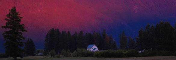
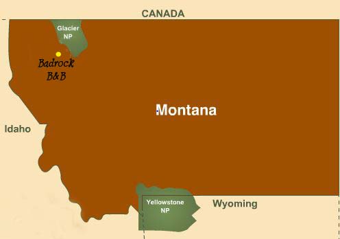
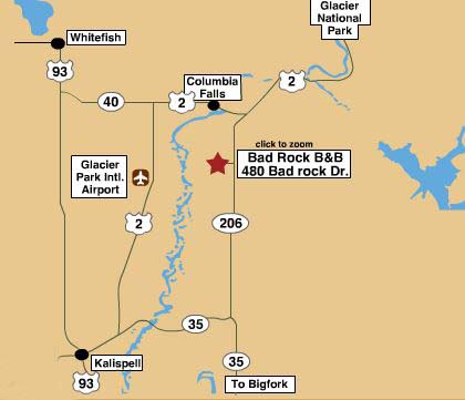
Location & Directions

To print a map, click on the detail that you
want and use your right mouse button to print, or Click here
Please do not rely on a GPS when traveling from the west. The old 4th Street Bridge has been closed to traffic over 25 years. However many new GPS systems still try to send the driver across it from Columbia Falls to our B&B. Just stay on Hwy 2 through Columbia Falls to Hwy 206. Go south and then the GPS will correct itself.
FROM I-90, GOING WEST FROM MISSOULA . Take the Highway 93 Exit,
five miles west of exit 101, (Reserve Street),
in Missoula. Follow Highway 93 north for 1 hour to Polson. The road climbs a short hill to a
breathtaking view of Flathead Lake and then drops downhill. At the bottom, just before entering
Polson, is the junction of Highway 35. Turn right onto Highway 35 and follow it for 45 minutes
to Bigfork. Now follow the instructions "From Bigfork" below.
FROM I-90, GOING EAST FROM IDAHO. Turn off at St. Regis,
exit 33 on I-90, go under the
freeway and continue on that road, Highway 135. The road sign reads "Montana 200/Paradise".
This road ends in about 23 miles at Highway 200. Turn right and follow Highway 200 31 miles
to Ravalli, where it ends at Highway 93. Turn left onto Highway 93, and take it north for 31
miles to Polson. The road climbs a short hill to a breathtaking view of Flathead Lake and
then drops downhill. At the bottom just before entering Polson, is the junction of Highway 35.
Turn right onto Highway 35 and follow it for 45 minutes to Bigfork. Now follow the
instructions "From Bigfork" below.
If you are interested in seeing the National Bison Range,
take the turnoff from Highway 200 just pass Dixon onto Highway 212. Upon leaving the Range,
continue on your trip be taking Highway 212 east to Highway 93, following it north to
Polson.
Because some of Montana's roads may lack adequate signage, the
following instructions include exact mileage figures. You will find it very helpful to
pay careful attention to your car's odometer.
FROM KALISPELL. Highway 93 becomes Main Street upon
entering Kalispell.
Continue north on Main, where there are a number of traffic lights, to the major intersection
of Main and Idaho. Idaho St is also Highway 2. The directional sign reads "Columbia Falls/West
Glacier". Turn right onto Idaho/ Highway 2 and go east 2.0 miles, (3.2 km) to the next
major intersection, staying in the right lane. This intersection is confusing. DO NOT
follow the directional signs reading "Columbia Falls/West Glacier". Stay in the right lane
without turning and go through the intersection. The road now becomes Highway 35 and the
directional sign reads "Bigfork". Stay on Highway 35 for 5 miles. At Hwy 206 signal light, go left (north) The sign reads Glacier Nat Park. There is a Conoco Station at the corner. Watch the mile markers on the right. After 7 miles our sign will be on the left at Bad Rock Drive. Turn left onto
Bad Rock Drive and go 0.8 miles (1.28 km) to the first stop sign. Cross the intersection
and go 0.1 miles to the first driveway on your left: Bad Rock Bed and Breakfast. There is a large boulder with our name and large metal bear at the driveway entrance.
FROM BIGFORK. The road north out of Bigfork is
Highway 35. About 2 miles north of Bigfork is the junction of Highway 83 to Swan Lake. Continue
north on Highway 35 from this junction 11.6 miles to the signal light at junction of Highway 206. Highway 35
turns west just before this junction, where there is a Conoco station and a small golf
course. The directional sign reads "Columbia Falls/West Glacier". Turn right onto Highway
206. Go 7.1 miles (11.36 km) north on Highway 206 to Bad Rock Drive. A "Frey's Meat
Cutting" sign is on the left just before Bad Rock Drive. Our sign is on the LEFT, northwest corner of the intersection. Turn left onto
Bad Rock Drive and go 0.8 miles (1.28 km) to the first stop sign. Cross the intersection
and go 0.1 miles to the first driveway on your left: Bad Rock Bed and Breakfast.
FROM WHITEFISH. Go south on Highway 93 out
of Whitefish about 2 miles (3.2 km). Look for a sign on the right side of the road reading
"Columbia Falls/West Glacier" and a traffic light. Turn left here onto Highway 40.
Go 4.4 miles (7 km) east on Highway 40 to the junction with Highway 2. The road becomes
four lanes and is now called Highway 2. Continue east for another 4.3 miles (6.9 km),
through the town of Columbia Falls, to the junction of Highway 206, just past the
"Big Sky Waterslide" park. Stay in the right lane and turn right onto Highway 206.
Go south 2.4 miles (3.8km) to Bad Rock Drive. Our sign and is on the right,which is the northwest corner of the intersection. Turn right
onto Bad Rock Drive and go 0.8 miles (1.28 km) to the first stop sign. Cross the intersection
and go 0.1 miles to the first driveway on your left: Bad Rock Bed and Breakfast.
FROM GLACIER NATIONAL PARK AT WEST GLACIER.
From the railroad track underpass at West Glacier turn right onto Highway 2 West. It is 10
miles (16 km) to the town of Hungry Horse. It is 5 more miles (8 km) to the junction of
Highway 206. Turn left (south) at the traffic light onto Highway 206. The directional
sign reads "Bigfork". Go south from the intersection 2.4 miles (3.8km) to Bad Rock Drive.
Our sign is on the right, the northwest corner
of the intersection. Turn right onto Bad Rock Drive and go 0.8 miles (1.28 km) to
the first stop sign. Cross the intersection and go 0.1 miles to the first driveway on
your left: Bad Rock Bed and Breakfast.